Monday, April 23, 2012

one of six over 18 inches after work last week. This one was over two feet! Sorry buddy, go back to spawning.

looking up at "Super Gully" from  almost 10,000 feet. I accended the gully and ridge system to the climber's right of Super Gully. Firm snow made for excellent cramponing.  I counted 10 different ways to walk uphill with crampons.

Looking down Super Gully from  over 12,000 feet, wondering if it will thaw. In the middle of a perfect weather window...high pressure, hight temps, no clouds...orographic lifting sometimes squeezes out just a bit more moisture from the atmosphere, enough to produce intermittent clouds near the summit, preventing my line from thawing. Dang it! No shame, I side stepped the first 400 feet or so, then skied in survival mode for a few hundered more feet. That first third of the gully took about half an hour and a few more nanometers of my hairline. The last two thirds  had  thawed and took me about one minute to ski during which  time my hairline actually advanced several nanometers!

False summit, the real summit is 1/3 of a mile farther but only 50 feet higher.

This is looker's left of Super Gully. I climbed to this point, about 11,000 feet, and waited for the surface to thaw, but it never did. Note water ice.

Mountains, desert, reservoir

Trail Head

Lost River Peak, April 2012

Monday, April 9, 2012


These shoes need to be a half size bigger. After showering in these shoes I wore them as long as i could. Then, to avoid shrinkage...


Actually, its still skiing season. I headed back up towards Leatherman Pass and made my way up the north ridge of that peak. At some point I was stopped by steep snow covered rocks. To glisse the face just east of the ridge seemed like the best option (first photo). Two or three nice couloirs were draped down the face. Ankle deep powder at 45 degrees for about 1,500 feet took me to a horizon line which, nicely, turned out to not be death cliffs...mearly a rollover of a few degrees which led quickly to lower angle slopes and then the floor of the basin (photo with sick tracks).


As an after thought, I figured I'd go around and try to summit via the west face. I made it a few hundered feet closer, but was stopped by exhaustion. I then skied one of the biggest, best corn runs of my life, but was too waxed to fully enjoy the ride.

Monday, April 2, 2012

LRR heating up


The wetter snow of spring is apparently what it takes to stick to Lost River Range. A few good freeze/thaws has ensured that the snow will not blow away. Finally, endless scree has been transformed to a cruiser skin track.


I headed up sawmill gulch which, if you have an ATV, can be followed with some difficulty pert near the pass between the two named peaks in the photo. I grew up in the suburbs, so my vehicle only made it about a mile past where this photo was taken.


April fools day...after an hour of hiking and two hours of skinning I discovered that I had inadvertantly brought more than the usual 1.5 litres of water. Somehow I had four litres!


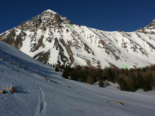
As sometimes happens, I forgot my camera (ipod). The image I most regrett not having is one of the titanic leatherman, splitting sawmill gulch with its perfect equillateral triangle burning white. Pretty much looked like K2 from that aspect. From there I headed climbers left toward the unnamed summit on the photo's left (with green arrow). This pittance of a summit tops out at only 11,000 ft. The looker's right couloir off the summit went well. Warm weather the week prior gave rise to several point releases, but no fracturing. On this day everything was frozen solid and covered in an inch of fresh...and no wind! After negotiating rocks and avi debris the chute turned into a low angle half pipe full of ankle deep pow that extended well below tree line. This run had it all: steeps, tech, rocks, ice, vert, pow, location, access! 2,300 feet.